RYA Training Chart TC6 - Southern Hemisphere
| Author: | Royal Yachting Association |
|---|---|
| Edition: | 2006 |
| Format: | Folded Chart |
RYA Training Chart TC6 - Southern Hemisphere is backordered and will ship as soon as it is back in stock.
Couldn't load pickup availability
Delivery Information
Delivery Information
We aim to dispatch all orders by the next business day, but we're a small business and sometimes when it's busy it may take a little bit longer. If there's going to be any delays we'll get in touch and keep you up-to-date.
Shipping is free for all orders of £50 or more!
We work with Royal Mail, DPD and DHL to offer the most convenient delivery options to our customers.
Friendly Advice
Friendly Advice
Chris is a Master Mariner and knows a thing or two about seafaring. If you need any help then don't be shy - send us an email or get in touch using the WhatsApp icon.
Easy Returns
Easy Returns
Not what you were looking for? No problem. We can accept returns of items in as-sold condition for up to 30 days (maybe a bit longer but don't tell anyone).
Just let us know and we'll sort everything out, including the shipping cost back to us.
Unfortunately this doesn't apply to Print on Demand charts as they are correct at the time of printing.
Of course if there's any faults or damage then let us know and we'll make it right!
Practice Makes Perfect
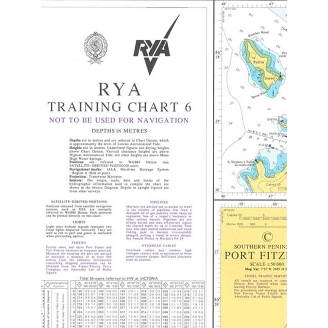
Ready to hone your chartwork skills and prepare for real-world navigation challenges? The "RYA Training Chart TC6 - Southern Hemisphere" is your indispensable tool, providing a meticulously crafted fictitious coastline for practicing essential navigation techniques.
Learn by Doing: Explore a detailed chart, complete with latitude and longitude lines, depth soundings, coastal features, and navigational aids. This training chart, prepared by the UKHO specifically for the RYA, allows you to apply your knowledge in a safe and controlled environment.
Essential for RYA Courses: Ideal for students enrolled in RYA courses, this chart complements your theoretical learning with hands-on practice. Sharpen your skills in chart plotting, position fixing, course planning, and tidal calculations, ensuring you're prepared for any situation on the water.
Perfect for Self-Study: Even if you're not enrolled in a formal course, this chart is a valuable resource for independent learning. Challenge yourself and enhance your navigational skills in the comfort of your own home.
Realistic Coastline: Navigate a diverse coastline with realistic features, including bays, headlands, islands, and navigational hazards. Practice plotting courses, taking bearings, and interpreting tidal information, building your confidence and competence.
Disclaimer: Please note that this product is for training purposes only and should not be used for actual navigation.
-
AuthorRoyal Yachting Association
-
Edition
-
Format
-
ISBN
Payment & Security
Payment methods
Your payment information is processed securely. We do not store credit card details nor do we have access to your credit card information.

