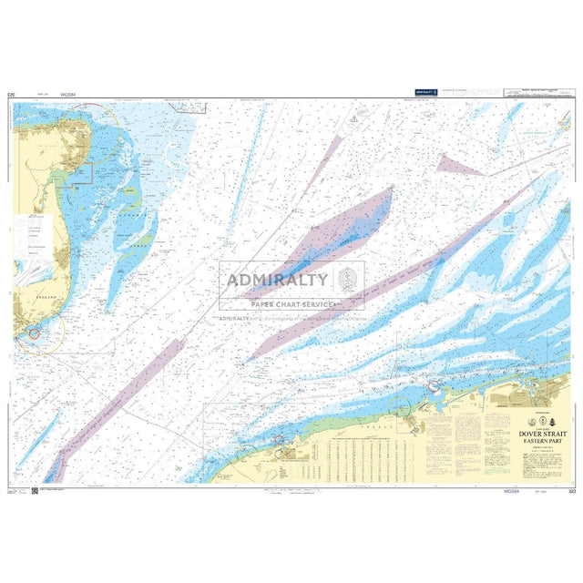
Admiralty Chart 323: Dover Strait Eastern Part
| Edition: | March 2026 |
|---|---|
| Corrected to: | Date of order |
| Format: | Printed to order on Admiralty chart paper |
| Scale: | 1 : 75,000 |
| Size: | Please see description |
Admiralty Chart 323: Dover Strait Eastern Part - 26 Mar 2026 / Folded is backordered and will ship as soon as it is back in stock.
Delivery Information
Delivery Information
Friendly Advice
Friendly Advice
Returns
Returns
Admiralty Chart 323: Dover Strait Eastern Part

Admiralty Chart 323: Dover Strait Eastern Part - 26 Mar 2026 / Folded is backordered and will ship as soon as it is back in stock.
Official Admiralty Chart
Printed on demand with latest corrections applied.
An official Admiralty Standard Nautical Chart (SNC), printed on demand on quality, watermarked chart paper directly from the UKHO's latest digital files. Each chart includes all available corrections up to the date of printing, ensuring you receive the most up-to-date data for safe passage planning and navigation.
About Official UKHO Admiralty Charts
Admiralty Standard Nautical Charts (SNCs) are the world's most trusted and widely used official paper charts, produced by the prestigious UKHO. With over 200 years of experience, the UKHO is a global leader in hydrography, setting a benchmark for quality and accuracy relied upon by mariners worldwide. Each Admiralty chart is compiled by expert cartographers to meet exacting international standards, providing comprehensive coverage of commercial shipping routes, ports, and harbours. For professional mariners, these charts are a key tool for supporting safe navigation and helping to meet the chart carriage requirements of the International Convention for the Safety of Life at Sea (SOLAS).
Key Features of Admiralty Charts
- Comprehensive Coverage: Choose from over 3,500 UKHO charts covering deep-sea routes, coastal navigation passages, ports, and harbours around the world.
- Multiple Scales Available: Select from large, medium, and small-scale charts to get the right level of detail for your specific navigational requirements.
- Up-to-Date for Safe Navigation: Every nautical chart is printed on demand with the latest available corrections and official UKHO updates.
- Modern Features: Many charts now include a unique QR code linking to the UKHO's NM Websearch database for instant access to chart status and updates.
Nautical Charts for Framing & Decorative Wall Art
Authentic Admiralty charts make stunning pieces of nautical wall art for homes and offices. However, as these are working navigation charts rather than decorative prints, there are a few practical considerations for those wishing to frame them. Please review the key points below before ordering.
- Chart Dimensions: Most charts are approximately DE size (1070 x 715 mm), Long DE size (1270 x 715 mm) or A0 size (1189 x 841mm), though individual charts may differ. Some chart images are smaller and may be printed with a white border which can be trimmed. As exact dimensions aren't available until printing we strongly recommend waiting to receive your chart before ordering a frame.
- Presentation: The chart will be printed from the latest file available. Sometimes this may be more up-to-date than the sample image on this page. Over the past few years the colour palette and general presentation of Admiralty charts has changed as new editions are published. For example, newer editions use a paler yellow for land compared to the traditional deeper 'mustard' colour. If this is of concern please get in touch and we can check the latest thumbnail image.
- Official Markings: Charts will include an official agent's stamp and a line of authentication data in the margin.
- Folded or Unfolded: By default, charts are folded up to three times to a standard size suitable for a ship's chart drawer. If you require an unfolded chart for framing, please select this option when ordering. Both folded and unfolded charts are then rolled for shipping in a tube.
Shipping and Handling
- Printed to Order: Please note that Admiralty charts are not off-the-shelf items. Each one is printed on demand by an official UKHO Print-on-Demand distributor and prepared individually, a process that involves printing, trimming, quality checking, folding, official stamping, and applying a chart number label to the back of the chart. Please check for messages regarding current handling times during the ordering process.
- Urgent Orders: If you are in a hurry, please get in touch with us directly and we will do our very best to accommodate your needs.
- Packaging: Your chart will be shipped rolled in a sturdy cardboard tube. Charts are produced to professional navigation standards where minor creasing, if it occurs, does not affect navigational use. If shipped with Royal Mail we use a standard round tube. If shipped with DPD we use a long rectangular box which carries a slightly higher risk of creasing. Minor creasing can usually be flattened easily with a few hours under some heavy books.
- Returns: Because every chart is printed to order, it is non-returnable unless faulty or damaged. Please ensure the chart you have selected meets your needs before ordering. We are very happy to help with any questions, so please get in touch if you need assistance.
-
Format
-
Edition Number
-
Edition Date
-
Corrected to
-
TypeApproach
-
Scales1 : 75,000
-
HarboursDunkerque, Dover, Ramsgate, Gravelines, Calais
-
Sea AreaNorth Sea, English Channel, Dover Strait
-
CountryUnited Kingdom, England
-
AreaUK and Ireland
Payment & Security
Payment methods
Your payment information is processed securely. We do not store credit card details nor have access to your credit card information.