Choosing the right chart is hugely important. You place immense trust in your charts to keep you safe on passage, and finding the right fit for you can take a bit of thought.
We know this is a tough decision, especially with two big names to choose from: Admiralty and Imray. We're a family run business with over 10 years experience and a Master Mariner at the helm so hopefully this article will give you something to think about! We'd love to hear your comments down below so that we can keep this article fresh as time goes by.
We'll look at the pros and cons of Admiralty and Imray charts as well as the different formats available from each so you can make the right decision for your next sailing trip.
Admiralty Charts: The Choice of Professionals

Produced by the UK Hydrographic Office (UKHO), Admiralty charts are known for their accuracy, adherence to international standards and attention to detail. Used by professional mariners worldwide for commercial shipping and naval operations they are also a popular choice for leisure sailors who value their traditional feel.
Key features of Admiralty charts:
- History and Authority: Admiralty charts are recognised and respected worldwide. They're made by the UKHO, the government's hydrographic agency.
- Comprehensive Coverage: Admiralty charts have global coverage, though not necessarily for the small craft sailor - read more below.
- Meticulous Detail: These charts are known for their attention to detail providing a wealth of information about depths, hazards, navigational aids and more.
- Variety of Formats: All Admiralty charts are print-on-demand so you get the most up to date information. They have two product lines:
- Standard Nautical Charts: Large format charts with worldwide coverage suitable for professional and leisure use. Priced at £35.
- Small Craft Charts: A2 size charts focused on UK and Ireland waters for small boat navigation. Priced as low as £3.75 per chart.

Here's a to-scale comparison of the sizes of both types of charts.
Pros and Cons of Admiralty Charts:
| Pros | Cons |
|---|---|
| Highly accurate and reliable | Can be more expensive than Imray charts |
| Adhere to international standards | Not water resistant |
| Comprehensive global coverage | May appear cluttered to some users |
| Meticulous detail (at the right scale) | Not quite as curated as Imray - you may need more charts at different scales where a single Imray chart would do |
| Printed on demand - you'll always get the latest edition with all corrections applied | Small craft coverage is limited to the UK and Ireland - if you're going further afield you'll need Imray charts or expensive (and big) Standard charts |
| Pick and choose which charts you need - no need to buy a full folio/pack | Not much in the way of extras, e.g. no digital downloads or useful harbour information |
Spotlight on Admiralty Small Craft Charts:

Admiralty Small Craft Folios (click to see the range)
If you're sailing around the UK and Ireland you'll find that Admiralty Small Craft Charts are a great option. These A2 size charts are print-on-demand so you get the most up to date information every time - always the latest edition and fully corrected to the latest Notice to Mariners. The UKHO use data from their Standard Nautical Charts and produce these Small Craft Charts in a smaller size and at a range of scales.
Key benefits of Admiralty Small Craft Charts:
- Regular corrections: Weekly Notices to Mariners are available online so you have the latest safety critical information.
- Convenient size: The A2 format is perfect for smaller chart tables.
- Comprehensive supporting information: Each folio has a supporting document available on the Admiralty website which includes chart notes, distress and safety communication information, tidal curves and tidal stream tables.
- Cost effective: Charts start at £15 each but there are discounts for bulk orders. 5-9 charts are £9.75 each, 10-14 are £5.25 each and 15+ are £3.75 each. This means 5 charts are cheaper than 4 and 16 charts are the same price as 4! Confusing? A little bit - but we've done the maths!
Imray Charts: Designed for the Leisure Sailor

Imray's history goes back centuries but it was in the early 1900s when the company we know today came to life. Once a real contender to Admiralty in the world of commercial charts, Imray have now focused their business on leisure sailors. They know their stuff too - just look at their range of pilot books and cruising guides. They use the same data from international hydrographic offices but their real asset is their network of sources including local knowledge gathered through their pilot books and cruising guides.
Key features of Imray charts:
- Clarity and Ease of Use: Imray charts prioritise clarity and ease of use.
- Durable, Water-Resistant Paper: Imray single charts are printed on Pretex paper which is coated for water-resistance, durability and which stands up well to folding.
- Convenient Formats: Imray offer chart packs and individual charts so there's a lot of choice.
- Good coverage of popular cruising areas: The Imray chart range covers much of Europe, the Caribbean and the Atlantic Islands.
- Efficient Use of Space: Imray use “dead space” on their charts to include extra information such as harbour insets, tidal information and local contact details. They're pretty smart when it comes to maximising the information on a single sheet.
- Plastic wallets!: Never underestimate how useful these are. Sadly not available with Admiralty charts any more.

Imray Chart Series:
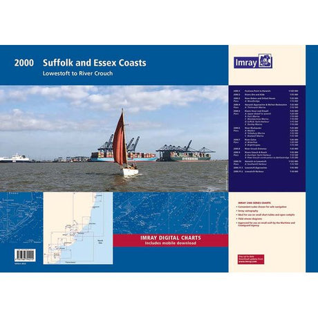
Imray offer individual charts in various series and chart packs covering wider areas. All Imray single charts are folded to A4 size and come in a plastic wallet. Chart packs are A2 size and come in a plastic wallet. They are available loose-leaf or spiral bound.
Imray's C Series single charts cover North West Europe
| Series | Coverage | Size (mm) |
|---|---|---|
| C Series | North West Europe | 787 x 1118 |
| Y Series | UK rivers, estuaries, and coastal areas | 640 x 900 |
| M Series | Mediterranean Sea | 640 x 900 |
| A/B/D Series | Caribbean | 640 x 900 |
| E Series | Atlantic Islands | 640 x 900 |
| G Series | Ionian and Aegean Seas | 640 x 900 |
| Chart Packs | NW European waters, Brittany, Mediterranean Spain | 420 x 594 |

Imray's M Series single charts cover the Mediterranean Sea
| Pros | Cons |
|---|---|
| User-friendly and easy to read | May not be as detailed as Admiralty charts, though the detail is carefully curated and this is more about scale - the Chart Packs offer good variety of scale |
| Water resistant (except for chart packs) | The colours can take a little bit of getting used to for those used to Admiralty charts |
| Convenient formats, including single charts and chart packs | Single charts are great for coastal passages but large-scale (zoomed-in) coverage may not be quite as good |
| Packed with information curated for the leisure sailor | Some may find the packed-in extras (plans etc) a bit cluttered |
| Charts come with a voucher to download the charts into the Imray Navigator app | Some users find the paper less suitable for drawing on and the colours difficult to read under red light (tip from Chris - use a 2B pencil - like the little ones they provide in Ikea!) |

One of Imray's chart packs
Imray Chart Packs vs Admiralty Small Craft Charts
Imray Chart Pack Coverage
When it comes to choosing charts, many sailors are drawn to the convenience of chart packs or folios. These collections provide a ready-made set of charts for a particular area, and there's a lot to be said for ready-made - it's a lot less work after all! They're particularly useful for areas you spend a lot of time in or for those trips where you're not quite sure where you'd like to make your home for the night.
Both Imray and Admiralty offer great options in this category each with their own advantages.
Let’s take a closer look at Imray Chart Packs and Admiralty Small Craft Charts and help you decide which one is right for you.
| Feature | Imray Chart Packs | Admiralty Small Craft Charts |
|---|---|---|
| Format | A selection of charts covering a specific region, packaged in a durable plastic wallet. | Individual A2-sized charts that can be combined to create a folio for a specific area. |
| Choice | Pre-made packs - you buy all the charts for the selected area | Pick and choose, mix and match - buy only the charts you need |
| Paper | Heavy-duty chart paper | Heavy-duty chart paper |
| Packaging | Plastic wallet | None, though SailorShop will ship in a sturdy cardboard tube |
| Water resistance | Not water resistant (only the single charts are) | Not water resistant |
| Coverage | UK and Ireland coastal waters, Southern North Sea and Mediterranean Spain | UK and Ireland coastal waters. |
| Updates | Weekly updates available, sometimes even more up to date than Admiralty as they can process them faster | Updated weekly with Notices to Mariners. |
| Supplementary data | On the charts | In a separate document |
| Cost | £59.95 for loose-leaf or £64.95 for spiral-bound | £16.20 per chart with stepped discounts based on quantity: up to 75% off for 15 or more charts |
Let's talk about colours...
Ask any sailor what is is they like about their preferred brand and we guarantee that colours will be mentioned. So here's a guide to each brand's colour schemes:

Why the differences? Well Admiralty charts follow an international standard colour system - all of the world's chart-producing hydrographic offices use these colours and they're matched on official Electronic Navigational Charts which commercial ships use. Remember that large ships use these charts to cross oceans - the white deep areas offer a clean background for plotting and for reading chart details. When you encounter colour you know you need to, well, pay more attention!
On the other hand, Imray aren't constrained by the international standards and they've gone with a scheme that makes a bit more sense to those who are used to "land maps". Lovely green land, golden sandy beaches and deep blue sea.
Choosing the Right Chart for Your Needs
When it comes down to it, the choice between Admiralty and Imray charts depends on your individual needs and preferences. Consider the following:
- Sailing Area: Both Admiralty and Imray have got the UK and Ireland covered, but watch out for the differences. Imray Chart Packs don't cover the south coast of Ireland, for example, or the north east coasts of England and Scotland - but they have C Series charts that do. It may be that one option simply has better coverage for your voyage. For international voyages or less charted areas Admiralty standard charts might be the way to go due to their global coverage and adherence to international standards, but remember these are big commercial charts and they come at a cost.
- Experience Level: If you’re a less experienced sailor Imray’s user friendly format might be easier to use. It makes sense in some ways - the colours are like the maps we're used to - green for land, yellow for drying areas (yellow for sand seems pretty obvious) and blue for deep water.
- Personal Preference: Some might prefer the "look and feel" of either brand. You may have taken an RYA course where their training charts look a lot like Admiralty. Or you might have a Merchant Navy or Royal Navy background and be a bit stubborn, like Chris, who is firmly in the Admiralty camp even though he's well aware that Imray charts are better in some ways. Consider your personal preference for colour schemes, level of detail and format.
Combining Charts and Other Resources
You can, of course, combine different types of charts and navigational resources. For example you might use Imray charts for coastal cruising and supplement with Admiralty charts for specific areas or longer passages.
Don’t forget the value of pilot books and almanacs. These will provide valuable information and enhance your navigation.
And make sure you have a supply of good chartwork instruments to use with your charts.
Why Choose SailorShop.co.uk?
At SailorShop.co.uk we want to help you find the right charts for your needs. We offer:
- Huge Range: We stock a vast range of both Admiralty and Imray charts so you can get the latest versions and the most suitable format for your voyages.
- Expert Knowledge: We know a thing or two about sailing. Chris and Slav are always happy to give you personal advice to help you choose the right charts for your requirements.
- Competitive Prices: We offer competitive prices on all our charts and have regular special offers to help you save.
- Fast and Reliable Delivery: We deliver fast and reliably throughout the UK so you get your charts quickly and in perfect condition. We also offer free delivery on orders over £50.
Set Sail with Confidence!
Whether you choose Admiralty, Imray or a combination of both, SailorShop has got you covered with the charts, books and instruments you need for safe and enjoyable sailing. Browse our charts, get in touch for advice and set sail!
We really hope that you've found this article useful - let us know if you think we've got anything wrong or if you have any stories to share. We'd love to keep this article up-to-date with your input!


