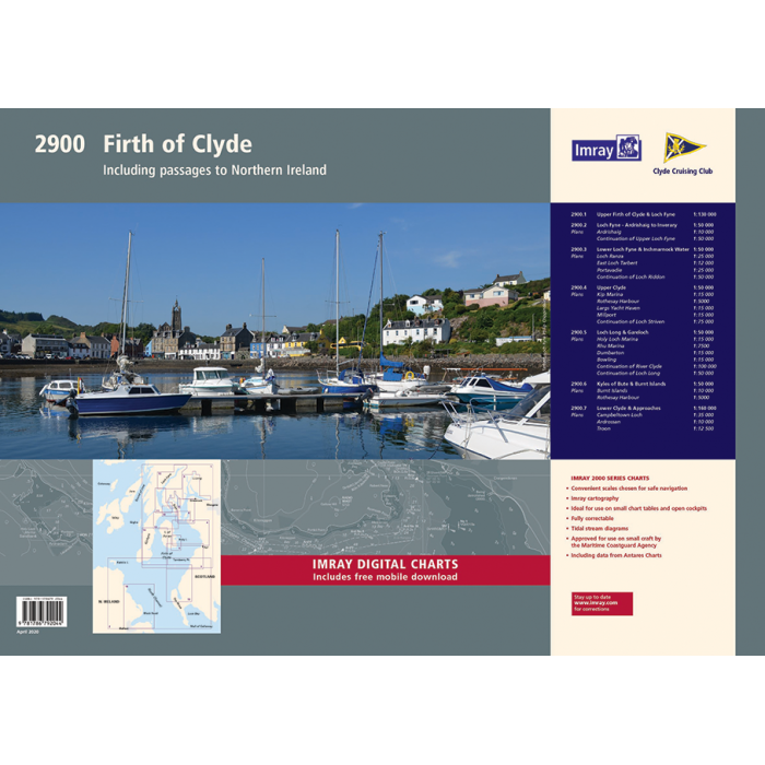
Imray Chart Pack 2900: Firth of Clyde including passages to Northern Ireland
| Edition: | 2020 |
|---|---|
| Corrected to: | May-20 |
| Format: | Loose-leaf cartridge paper in plastic wallet |
| Size: | 590 x 420mm (A2) |
Imray Chart Pack 2900: Firth of Clyde including passages to Northern Ireland is backordered and will ship as soon as it is back in stock.
Couldn't load pickup availability
Delivery Information
Delivery Information
We aim to dispatch all orders by the next business day, but we're a small business and sometimes when it's busy it may take a little bit longer. If there's going to be any delays we'll get in touch and keep you up-to-date.
Shipping is free for all orders of £50 or more!
We work with Royal Mail, DPD and DHL to offer the most convenient delivery options to our customers.
Friendly Advice
Friendly Advice
Chris is a Master Mariner and knows a thing or two about seafaring. If you need any help then don't be shy - send us an email or get in touch using the WhatsApp icon.
Easy Returns
Easy Returns
Not what you were looking for? No problem. We can accept returns of items in as-sold condition for up to 30 days (maybe a bit longer but don't tell anyone).
Just let us know and we'll sort everything out, including the shipping cost back to us.
Unfortunately this doesn't apply to Print on Demand charts as they are correct at the time of printing.
Of course if there's any faults or damage then let us know and we'll make it right!

Imray Chart Pack 2900: Firth of Clyde including passages to Norther...
Essential Charts for the Firth of Clyde & Passages to Northern Ireland
This completely redesigned A2 chart pack offers extensive coverage of the Firth of Clyde, including the Kyles of Bute, Loch Fyne, and Kilbrannan Sound. Created in association with the Clyde Cruising Club, it is designed for use alongside their sailing directions, making it an essential companion for cruising this spectacular region of Scotland. This edition also includes detailed charts for passages to Northern Ireland via the North Channel.
What’s Inside
This chart pack includes a range of charts for safe and efficient navigation:
- Small-Scale Passage Charts – Overview charts for offshore and coastal route planning.
- Coastal Charts – Covering inshore waters and key sailing areas.
- Approach Charts – Detailed plans for harbour entries and river mouths.
- Large-Scale Harbour Charts – Close-up views of marinas, anchorages, and port facilities.
Features of Imray Chart Packs
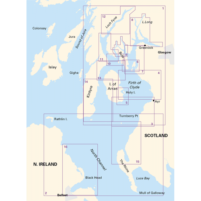
- Expanded Coverage – Includes passages from the Firth of Clyde and Loch Ryan to Belfast Lough.
- Detailed Charts – 16 sheets covering passage planning, approaches, and anchorages.
- Clyde Cruising Club Collaboration – Designed for use with their sailing directions.
- Free Digital Charts – Includes a voucher to download ID30 Imray digital charts in the Imray Navigator app.
- Comprehensive Information – Covers lochs, islands, and sailing areas recommended for small craft.
- Regular Corrections – Stay up to date with the latest navigational changes.
Important Note
This listing is for the loose-leaf format. If you prefer the spiral-bound edition, please search our shop.
Due to Royal Mail size restrictions loose-leaf chart packs are sent gently folded in half (not a sharp crease or fold).
If you require completely flat charts, please select DPD as your delivery option.
About Imray
Imray, Laurie, Norie & Wilson Ltd. has a heritage dating back to the mid-1700s, originally serving merchant ships in London's docks. Now an independent, family-run business, Imray is the only private chart publisher approved by the Maritime and Coastguard Agency for use on coded and fishing vessels under 24 metres. Their small team of expert cartographers and editors collaborates with the sailing community to produce world-renowned charts and cruising guides.
Imray charts blend official hydrographic data with verified small craft information, making them ideal for coastal navigation. Their distinctive colour scheme enhances clarity, and the charts are regularly updated for accuracy. Beyond paper charts, Imray offers digital navigation solutions, including electronic charts and the Explore with Imray app, giving sailors access to thousands of locations from their renowned cruising guides.
Charts Included
- 2900.1 – Firth of Clyde (1:210,000)
- 2900.2 – The North Channel (1:210,000)
- 2900.3 – Ailsa Craig to Ayr (1:75,000)
- Girvan (1:6,000)
- Ayr (1:10,000)
- 2900.4 – Ayr to Ardrossan (1:75,000)
- Troon (1:12,500)
- Irvine (1:17,500)
- Ardrossan (1:10,000)
- 2900.5 – Pladda to Lamlash Harbour (1:30,000)
- 2900.6 – South of Bute & the Cumbraes (1:30,000)
- Millport (1:15,000)
- Largs Yacht Haven (1:15,000)
- 2900.7 – Upper Clyde (1:50,000)
- Kip Marina (1:15,000)
- Rothesay Bay (1:10,000)
- Rothesay Harbour (1:5,000)
- 2900.8 – Long Loch & Gareloch (1:50,000)
- Continuation of Long Loch (1:50,000)
- Continuation of River Clyde (1:100,000)
- Dumbarton (1:15,000)
- Bowling (1:15,000)
- Approaches to Rhu (1:15,000)
- Holy Loch Marina (1:12,500)
- 2900.9 – Kyles of Bute (1:30,000)
- Continuation of Loch Striven (1:30,000)
- Continuation of Loch Riddon (1:30,000)
- Port Bannatyne Marina (1:10,000)
- Burnt Islands (1:10,000)
- Caladh Harbour (1:10,000)
- 2900.10 – Inchmarnock Water (1:30,000)
- 2900.11 – Lower Loch Fyne (1:50,000)
- Portavadie (1:25,000)
- East Loch Tarbert (1:8,000)
- Ardrishaig (1:10,000)
- 2900.12 – Upper Loch Fyne (1:50,000)
- Continuation of Loch Fyne (1:50,000)
- Loch Gair (1:25,000)
- Minard Narrows (1:25,000)
- Inveraray (1:25,000)
- 2900.13 – Inchmarnock to Kilbrannan Sound (1:50,000)
- Loch Ranza (1:22,500)
- 2900.14 – Carradale to Sanda Island (1:75,000)
- Campbeltown Loch (1:35,000)
- Campbeltown Harbour (1:7,500)
- Sanda Island (1:30,000)
- 2900.15 – Ailsa Craig to Loch Ryan (1:75,000)
- Stranraer (1:12,500)
- 2900.16 – Belfast Lough to Carnlough (1:90,000)
- Carrickfergus (1:15,000)
- Bangor Bay (1:17,500)
-
Edition
-
Corrected to
-
Format
-
Size
-
ISBN
Payment & Security
Payment methods
Your payment information is processed securely. We do not store credit card details nor do we have access to your credit card information.


