Channel Islands, Cherbourg Peninsula & North Brittany
| Author: | Peter Carnegie |
|---|---|
| Published: | 2023 |
| Format: | Hardback, 400 pages |
| Size: | 297 × 210 × 27 mm |
Channel Islands, Cherbourg Peninsula & North Brittany - Hardback / 2nd edition (2023) is backordered and will ship as soon as it is back in stock.
Delivery Information
Delivery Information
Friendly Advice
Friendly Advice
Returns
Returns

Channel Islands, Cherbourg Peninsula & North Brittany

Channel Islands, Cherbourg Peninsula & North Brittany - Hardback / 2nd edition (2023) is backordered and will ship as soon as it is back in stock.
Expert Tidal Guidance
Carnegie's years of exploration provide reassuring transit photos and practical advice for these fast-moving tidal waters.
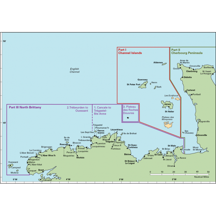
This popular pilot guide covers the waters of the Channel Islands and the neighbouring French coast from the northeast of the Cherbourg Peninsula westwards along the Normandy and Brittany coasts to Ouessant. Coverage includes the Plateau des Roches Douvres as well as detailed sections on the navigable rivers.
Peter Carnegie’s detailed and extensive exploration of these waters over many years is illustrated by his many photographs and accompanying plans detailing numerous transits to aid safe navigation in these waters of high tidal range and fast-moving currents.
Annabel Finding’s revision of the work includes updated port information and plans and a number of new photographs. This sailing region can appear daunting to the first-time visitor, but "Carnegie’s book provides reassurance and so much practical advice that anyone using it will feel confident of success." (Yachting Monthly).
Whether for your first cruise or to assist you in exploring some of the more challenging passages and anchorages, this is the definitive cruising guide and a must-have companion.
About Royal Cruising Club Pilotage Foundation
Imray has worked with the Royal Cruising Club Pilotage Foundation since 1985. The Foundation is a charity which collects and researches written, photographic and chart information relating to small boat pilotage, navigation and operation, climate and weather conditions, including information from remote areas of the world where other sources of information are scarce or non-existent.
The authors who work with the Foundation are respected and experienced cruising sailors, with thousands of nautical miles of cruising under their belts.
Once the Pilotage Foundation has researched and edited the material about a particular cruising area, Imray shapes it into a book, creating the cartography (often where there is very little official survey data as a source) and combining this with the manuscript and photos to create a new cruising guide.
About Imray
Imray has been publishing nautical information for recreational and professional mariners since the mid-18th century. Originally a family business, the company retains continuity through generations of maritime knowledge. Today, Imray is part of FB Imray, a joint venture with freytag & berndt (Austrian cartographic specialists). This has allowed them to combine traditional expertise with modern production methods.
Imray is recognised by the Maritime and Coastguard Agency as a chart producer. Their portfolio extends beyond paper charts to include pilot books, cruising guides, almanacs, and navigation handbooks.
-
ISBN
-
Pages
-
Author
-
Publisher
-
Imprint
-
Language
-
Edition
-
Published
-
Height (mm)
-
Width (mm)
-
Depth (mm)
-
Weight (g)
-
HarboursSt Peter Port, St Helier, Alderney, Bays of Sark, Cherbourg, Barfleur, Saint-Vaast-La-Hougue, Carteret, Granville, St-Malo, Erquy, Dahouët, Binic, St-Quay-Portrieux, Paimpol, Lézardrieux, Tréguier, Perros-Guirec, Morlaix, Roscoff
-
AreaUK and Ireland, Northern Europe
-
Sea AreaEnglish Channel
-
CountryChannel Islands, France
Payment & Security
Payment methods
Your payment information is processed securely. We do not store credit card details nor do we have access to your credit card information.