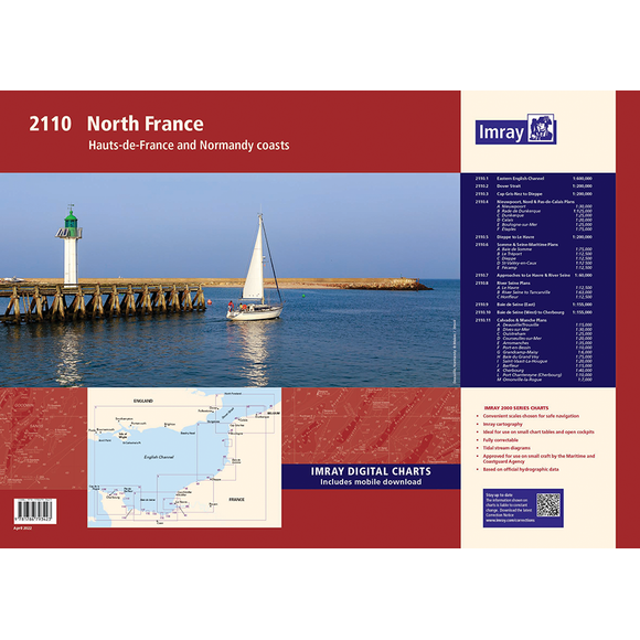
Imray Chart Pack 2110: North France
| Edition: | 2022 |
|---|---|
| Corrected to: | Apr-22 |
| Format: | Loose-leaf cartridge paper in plastic wallet |
| Size: | 590 x 420mm (A2) |
| Note: | Due to Royal Mail size restrictions loose-leaf packs are sent gently folded in half (not a sharp crease/fold). If you would prefer completely flat please select DPD for delivery. |
Imray Chart Pack 2110: North France is backordered and will ship as soon as it is back in stock.
Delivery and Shipping
Delivery and Shipping
We aim to dispatch all orders by the next business day, but we're a small business and sometimes when it's busy it may take a little bit longer. If there's going to be any delays we'll get in touch and keep you up-to-date.
Shipping is free for all orders of £50 or more!
We work with Royal Mail, DPD and DHL to offer the most convenient delivery options to our customers.
Advice
Advice
Chris is a Master Mariner and knows a thing or two about seafaring. If you need any help then don't be shy - send us an email or get in touch using the WhatsApp icon.
Returns
Returns
Not what you were looking for? No problem. We can accept returns of items in as-sold condition for up to 30 days (maybe a bit longer but don't tell anyone).
Just let us know and we'll sort everything out, including the shipping cost back to us.
Unfortunately this doesn't apply to Print on Demand charts as they are correct at the time of printing.
Of course if there's any faults or damage then let us know and we'll make it right!

Imray Chart Pack 2110: North France
Essential Charts for Hauts-de-France & Normandy
Navigate the captivating coasts of Hauts-de-France and Normandy with the fully revised Imray Chart Pack 2110. This convenient loose-leaf A2 chart pack, presented in a sturdy plastic wallet, is your ideal companion for exploring these picturesque waters. Combining the latest official UKHO, SHOM & Belgium hydrographic data with Imray's unique insights, it's perfect for small craft adventures.
What’s Inside
This chart pack includes a range of charts for safe and efficient navigation:
- Small-Scale Passage Charts – Overview charts for offshore and coastal route planning.
- Coastal Charts – Covering inshore waters and key sailing areas.
- Approach Charts – Detailed plans for harbour entries and river mouths.
- Large-Scale Harbour Charts – Close-up views of marinas, anchorages, and port facilities.
Features of Imray Chart Packs
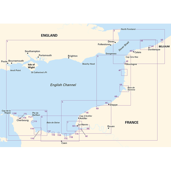
- Comprehensive Coverage – 11 detailed charts covering the region from the Eastern English Channel to Cherbourg.
- Latest Hydrographic Data – Incorporates UKHO, SHOM & Belgium hydrographic information.
- Imray's Local Knowledge – Additional insights gathered by Imray’s extensive network.
- Includes Tidal Data – Essential for safe voyage planning.
- Free Digital Charts – Includes a voucher to download Imray digital charts in the Imray Navigator app.
- Regular Corrections – Stay up to date with the latest navigational changes.
Important Note
This listing is for the loose-leaf format. There is no spiral-bound version of this pack. Due to Royal Mail size restrictions, loose-leaf packs are sent gently folded in half (not a sharp crease or fold).
If you require completely flat charts, please select DPD as your delivery option.
About Imray
Imray, Laurie, Norie & Wilson Ltd. has a heritage dating back to the mid-1700s, originally serving merchant ships in London's docks. Now an independent, family-run business, Imray is the only private chart publisher approved by the Maritime and Coastguard Agency for use on coded and fishing vessels under 24 metres. Their small team of expert cartographers and editors collaborates with the sailing community to produce world-renowned charts and cruising guides.
Imray has announced plans to end chart production towards the end of 2025. While stock is currently good, availability may change, so it's best not to delay if you need these charts. We remain hopeful that someone will take over Imray’s chart business and continue producing these fantastic charts for the sailing community.
Charts Included
- 2110.1 – Eastern English Channel (1:600,000)
- 2110.2 – Dover Strait (1:200,000)
- 2110.3 – Cap Gris-Nez to Dieppe (1:200,000)
- 2110.4 – Nieuwpoort, Nord & Pas-de-Calais Plans
- Nieuwpoort (1:30,000)
- Rade de Dunkerque (1:125,000)
- Dunkerque (1:25,000)
- Calais (1:20,000)
- Boulogne-sur-Mer (1:25,000)
- Étaples (1:75,000)
- 2110.5 – Dieppe to Le Havre (1:200,000)
- 2110.6 – Somme & Seine-Maritime Plans
- Baie de Somme (1:75,000)
- Le Tréport (1:12,500)
- Dieppe (1:12,500)
- St-Valéry-en-Caux (1:12,500)
- Fécamp (1:12,500)
- 2110.7 – Approaches to Le Havre & River Seine (1:60,000)
- 2110.8 – River Seine Plans
- Le Havre (1:12,500)
- River Seine to Tancarville (1:63,000)
- Honfleur (1:12,500)
- 2110.9 – Baie de Seine (East) (1:155,000)
- 2110.10 – Baie de Seine (West) to Cherbourg (1:155,000)
- 2110.11 – Calvados & Manche Plans
- Deauville/Trouville (1:15,000)
- Dives-sur-Mer (1:30,000)
- Ouistreham (1:25,000)
- Courseulles-sur-Mer (1:20,000)
- Arromanches (1:35,000)
- Saint-Vaast-La-Hougue (1:20,000)
- Cherbourg (1:40,000)
-
Edition
-
Corrected to
-
Format
-
Size
Payment & Security
Payment methods
Your payment information is processed securely. We do not store credit card details nor have access to your credit card information.